

155 MPH Winds - Hurricane Ian Strengthens to Category 4 Ahead of Florida Landfall
GoLocalProv News Team
155 MPH Winds - Hurricane Ian Strengthens to Category 4 Ahead of Florida Landfall
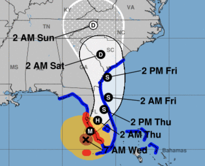
“Ian is a Category 4 hurricane packing maximum sustained winds of 155 mph as of 7:00 a.m. EDT Wednesday morning.
Bands of heavy rain containing strong wind gusts are lashing parts of the Florida Peninsula and the Florida Keys right now. Winds have recently gusted up to 55 mph on Sanibel Island, and a buoy near Ian's eye clocked a gust up to 94 mph.
GET THE LATEST BREAKING NEWS HERE -- SIGN UP FOR GOLOCAL FREE DAILY EBLASTWinds have gusted from 40 to 80 mph in Key West since Tuesday, where Ian also produced the third highest storm surge in over 100 years.
A tornado watch is in effect for central and southern Florida until 5 p.m. EDT.”
Florida Governor Ron DeSantis days ago declared a State of Emergency for 24 counties for the now-hurricane that the Weather Channel has declared “catastrophic.”