

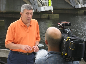
"A Storm Worth Watching Very Closely" - Ghiorse on Hurricane Lee
GoLocalProv News Team and Meteorologist John Ghiorse
"A Storm Worth Watching Very Closely" - Ghiorse on Hurricane Lee
"Hazardous surf and rip current conditions expected at beaches across the western Atlantic all week," they add.
GoLocal Meteorologist John Ghiorse provided his perspective on Lee on Monday afternoon.
GET THE LATEST BREAKING NEWS HERE -- SIGN UP FOR GOLOCAL FREE DAILY EBLAST
Ghiorse on the Record
While it seems very unlikely that we will see a direct hit from Hurricane Lee, it is certainly a storm worth watching very closely.
Latest projections for the track of the center of the storm bring it northward from its current position well south of Bermuda to a position 50-100 miles east of Cape Cod this weekend.
Obviously this far in advance, that projection could be off substantially. The projection "cone" from the National Hurricane Center indicates a potential position anywhere from the Cape Cod Canal to several hundred miles east of the Cape. In short, this far in advance, we have only a "ballpark" idea of where it will be several days from now.
That said, right now it is a very large and powerful storm. It is likely to lose its "tropical" characteristics as it trudges northward BUT it will still have very strong winds and a large wind field that will cause resulting massive seas, potential coastal erosion and flooding and beach rip currents.
We also can't rule out heavy rains and potential wind damage if the center comes close to us. In short, the main time frame of concern for us is this weekend. Stay tuned.