

“Blizzard Conditions” Predicted for RI: 8-17 Inches of Snow Possible, Wind Gusts of Up to 60 MPH
GoLocalProv News Team
“Blizzard Conditions” Predicted for RI: 8-17 Inches of Snow Possible, Wind Gusts of Up to 60 MPH
According to NWS, 8 to 17 inches of snow are now possible — and wind gusts of up to 60 miles per hour.
AccuWeather has predicted the storm will bring “blizzard conditions” to the easternmost portions of New England.
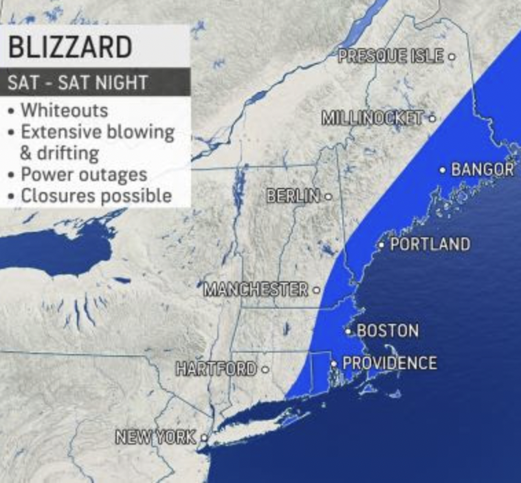
GET THE LATEST BREAKING NEWS HERE -- SIGN UP FOR GOLOCAL FREE DAILY EBLAST“A still-developing winter storm is set to become a major nor’easter that will bombard New England with heavy snow and blizzard conditions this weekend,” says AccuWeather.
“The intense storm has the potential to shut down airports, such as Boston Logan International Airport, and could lead to scores of flight cancellations in New York City, Philadelphia and Washington, D.C., that can have ripple effects across the nation as crews and aircraft are displaced,” said AccuWeather.
AccuWeather forecasters say that eastern New England will face the most significant impacts and that snow totals could reach or exceed a foot. There is the potential for some locations from eastern Connecticut, Rhode Island and eastern Massachusetts to southeastern New Hampshire and Maine to pick up between 2 and 3 feet of snow.
STORM WATCH
URGENT - WINTER WEATHER MESSAGE
National Weather Service Boston/Norton MA
333 AM EST Thu Jan 27 2022
MAZ007-013>023-RIZ001>008-272145-
/O.CON.KBOX.WS.A.0005.220129T0500Z-220130T0500Z/
Eastern Essex MA-Western Norfolk MA-Southeast Middlesex MA-
Suffolk MA-Eastern Norfolk MA-Northern Bristol MA-
Western Plymouth MA-Eastern Plymouth MA-Southern Bristol MA-
Southern Plymouth MA-Barnstable MA-Dukes MA-
Northwest Providence RI-Southeast Providence RI-Western Kent RI-
Eastern Kent RI-Bristol RI-Washington RI-Newport RI-
Block Island RI-
Including the cities of Gloucester, Foxborough, Norwood,
Cambridge, Boston, Quincy, Taunton, Brockton, Plymouth,
Fall River, New Bedford, Mattapoisett, Chatham, Falmouth,
Provincetown, Vineyard Haven, Foster, Smithfield, Providence,
Coventry, West Greenwich, East Greenwich, Warwick, West Warwick,
Bristol, Narragansett, Westerly, Newport, and New Shoreham
333 AM EST Thu Jan 27 2022
...WINTER STORM WATCH REMAINS IN EFFECT FROM LATE FRIDAY NIGHT
THROUGH SATURDAY EVENING...
* WHAT...Heavy snow possible. Total snow accumulations of 8 to 17
inches possible. Winds could gust as high as 60 mph, especially
on Cape Cod.
* WHERE...Portions of northern Connecticut and central, eastern
and northeastern Massachusetts.
* WHEN...From late Friday night through Saturday evening.
* IMPACTS...Travel could be very difficult to impossible. Strong
winds could cause tree damage.
PRECAUTIONARY/PREPAREDNESS ACTIONS...
Monitor the latest forecasts for updates on this situation.