

Weather Update: Up to 3 Inches of Snow Expected to Hit Providence Sunday Night
GoLocalProv News Team
Weather Update: Up to 3 Inches of Snow Expected to Hit Providence Sunday Night
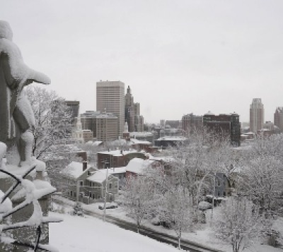
The National Weather Service says that there is 100% chance of snow Sunday night after 9 p.m. with up to 3 inches possible.
The snow is expected to change to rain before noon on Monday with up to a half an inch possible.
GET THE LATEST BREAKING NEWS HERE -- SIGN UP FOR GOLOCAL FREE DAILY EBLASTSee the Weather Service's Hazardous Weather Outlook Below
HAZARDOUS WEATHER OUTLOOK
NATIONAL WEATHER SERVICE TAUNTON MA
531 AM EST SUN DEC 11 2016
MAZ015>024-RIZ002>008-121045-
SUFFOLK MA-EASTERN NORFOLK MA-NORTHERN BRISTOL MA-
WESTERN PLYMOUTH MA-EASTERN PLYMOUTH MA-SOUTHERN BRISTOL MA-
SOUTHERN PLYMOUTH MA-BARNSTABLE MA-DUKES MA-NANTUCKET MA-
SOUTHEAST PROVIDENCE RI-WESTERN KENT RI-EASTERN KENT RI-BRISTOL RI-
WASHINGTON RI-NEWPORT RI-BLOCK ISLAND RI-
531 AM EST SUN DEC 11 2016
THIS HAZARDOUS WEATHER OUTLOOK IS FOR SOUTHEASTERN
MASSACHUSETTS...AND ALL OF RHODE ISLAND EXCEPT NORTHWESTERN RHODE
ISLAND.
.DAY ONE...TODAY AND TONIGHT.
A PERIOD OF LIGHT SNOW WILL OVERSPREAD THE REGION TONIGHT. AN INCH
OR TWO OF SNOW ACCUMULATION IS POSSIBLE...BEFORE A CHANGEOVER TO
RAIN BY DAYBREAK MONDAY.
A SIGNIFICANT IMPACT TO THE MONDAY MORNING RUSH HOUR IS LIKELY...
MAINLY NORTH AND WEST OF THE BOSTON TO PROVIDENCE CORRIDOR.
.DAYS TWO THROUGH SEVEN...MONDAY THROUGH SATURDAY.
NO HAZARDOUS WEATHER IS EXPECTED AT THIS TIME.
.SPOTTER INFORMATION STATEMENT...
SPOTTER ACTIVATION IS NOT EXPECTED AT THIS TIME.
25 Things You Must Do in New England This Winter - 2017

Ice Skating at Newport Skating Center
Newport, RI
Whether you are skating on a pond or at one of the many ice rinks across the region like the Newport Skating Center in the heart of Newport.
The skating center provides a full schedule of activities to carry you through the winter including adult and kids skating sessions as well as activities for the entire family.

Snowmobile at the Tall Timber Lodge
Pittsburg, New Hampshire
For snowmobiling enthusiasts, Pittsburg, New Hampshire might be the snowmobiling capital of New England with more than 200 trails, all filled with great adventures.
The Tall Timber Lodge offers a variety of packages that include rentals, dinners, lodging and much more. If you need a break from the trails, the lodge also consists of a spa.
PHOTO: Paul Williams

Dog Sled Tours at Ultimate Dog Sledding Experience
Oxford, Maine
Embrace the call of the wind and go up to New England Dog Sledding for dog sled tours. Tours are pulled by trained and "friendly" Husky sled dogs and are offered throughout the area.
Ultimate Dog Sledding is located just 40 minutes from Portland.
PHOTO: NPS/ JACOB W. FRANK/ Flickr

Get Out of the Cold and Into the Water at CoCo Key Boston
Danvers, MA
Get out of the cold and into the water at CoCo Key's 65,000 sq. ft. indoor water park in Danvers.
The park includes multiple water slides, tube rides, pools and so much more to take your mind off of winter, at least for a little while.
For those who might need a break from the water, there is an arcade with games for all ages.
PHOTO: Coco Key Facebook

Sled Down Neutaconkanut Hill
Providence, RI
Neutaconkanut Hill has some of the best slopes for sledding in the state.
Bundle up, hold on, and enjoy the ride.
In addition to the sledding slopes, snowshoeing and cross-country skiing are offered at this legendary Providence slope.
For more great places to sled, check out GoLocalProv's latest list.
PHOTO: Popofatticus/Flickr

Ice Climbing With Adventure Spirit
Burlington, Vermont
For the adventurous out there, Adventure Spirit in Vermont is your place for ice climbing. Choose from climbing at Bolton Quarry, Bristol Cliffs or even Smuggler's Notch to be lead by one of their experienced instructors.
Be prepared to spend your day strenuously climbing some of nature's frozen streams and flow offs. They also offer alpine climbing and outdoor rock climbing for those who wish to fully test their limits.
PHOTO: Adventure Spirit

Providence, RI
Providence Restaurant Weeks will take place from January 14 to January 27, 2018, with nearly 100 restaurants participating. Enjoy three-course lunches at $16.95 and three-course dinners at $29.95 or $34.95, as well as two-for-one specials.
Restaurants include Capriccio, Milk Money and many more.

Jump Around at Launch Trampoline Park
RI, MA or CT
Need to get some energy out? or get the energy out of your kids? Head to Launch Trampoline Park. They have a park in Rhode Island, Massachusetts, and Connecticut.
With dodgeball, basketball, foam pits and more, indoor trampoline parks have something to offer people of all ages. Whether you want to bring a group of children for the day or sign up a group of adults for some "xtreme" dodgeball, trampoline parks can be a great change of pace and a fun way to try something new.

Newport, RI
The 2017 Newport Winter Festival is set to be held from February 16-25.
The festival features live music, food, games, a chili cook-off and so much more over a span of nine days.

Indoor Rock Climbing
RI, MA or NH
Do you need a new challenge this winter? Try one of New England's indoor rock climbing gyms. Whether you choose Rock Spot Climbing in Rhode Island, Carabiner's in Massachusetts, or Vertical Dreams in New Hampshire, rock climbing is a fun and challenging way to get some exercise without running on treadmills.
Photo courtesy of Rock Spot Climbing

New England Pond Hockey Classic
Merideth, New Hampshire
You have never seen hockey like this.
The 8th annual New England Pond Hockey Classic kicks off on February 2 with final team rosters due on January 20. Get your team together and head up to New Hampshire.
If you can't make it up, grab the skates and find your local pond and play hockey anyway. BE SAFE of course.

Curling at Ocean State Curling Club
Cranston RI
You watch curling in the Olympics every year and you love it. So try it this winter.
The Ocean State Curling Club has your curling fix. Hosting events and tournaments or "bonspiels" at the Veteran’s Memorial Ice Rink in Cranston, RI, the Ocean State Curling Club is a "social club for anyone interested in recreational curling." The club also offers lessons for those who want to learn the sport.
Photo: dave/Flickr

Ice Fishing
Across New England
It's practically a tradition for a lot of people, but ice fishing is an interesting winter experience. Head out to the ponds and see what you can get.
But be safe, it takes 4-6 inches of ice to support a person and 8-10 inches to support a vehicle.
Photo courtesy of Dushan Hanuska/flickr

Get the House Organized
The weather isn't great, it's freezing outside. Winter presents a great opportunity to get the house organized. It's not the most fun thing in the world of course, but it will pay off and at the end of it, you will be glad you did it.
Here are some ways to get organized this winter.

Go Snowshoeing at Wachusett Mountain
Leominster, MA
For those who can't ski or snowboard, snowshoeing is another way to get around in the snow. Wachusett Mountain is the perfect place for snowshoeing.
PHOTO: Matt, just Matt

See the Lights at La Salette Shrine
Attleborough MA
By far one of the coolest lighting displays you will see anywhere in New England and maybe even the country.
The Festival of Lights runs from 5 p.m. to 9 p.m. every night until January 1.
Do not miss out!

Sing-a-Long with the Boston Pops at Symphony Hall
301 Massachusetts Avenue, Boston, MA
Held at Symphony Hall, the Boston Pops holiday concert is filled with food, sing-a-longs and a visit from the one and only Santa Claus!
Have some holiday cookies as the Boston Symphony Orchestra plays holiday classics for you and your family.
The seven kids afternoon shows include post-concert photos with Santa as well as special treats.
The concert runs until December 31.

Give to the Community
While the winter holidays are generally the biggest volunteer days of the year, any day of the year is a great time to give to organizations or people in need.
Items like food, clothes, and blankets are just some of the things that are needed most this time of year.
See Ways to Give in RI by Clicking Here.

First Night Hartford New Years Eve Celebration
Hartford, Connecticut
Join First Night Hartford for its 29th year of celebration! The multi-venue event will include performances by aerialists, Circophony Youth Circus, the Connecticut Academy of Irish Music, and Crafts and tours at Bulter McCook House.
Don’t forget to stay for the fireworks starting promptly at 6 p.m. with a second showing at midnight to ring in the New Year!

Mount Washington, Bretton Woods New Hampshire
Soar down Mount Washington on a series of tree-top zip lines! The Canopy Tour is lead by one of Bretton Woods Adventure Guides as they describe the native fauna and flora. You'll descend over 1000 feet of elevation on this 3-hour tour. Each tour guide can take a group of up to 8, so grab some friends and zip down the mountain!

Cross Country Skiing
East Bay Bike Path, Bristol to Providence RI
Grab your poles and skis and head down to the East Bay Bike Path for some Cross Country Skiing. Of course, you can go cross-country skiing anywhere there is snow and some flat land, but the East Bay Bike Path stretches about 14 miles from Bristol to India Point Park in Providence.

Ride the Polar Express
Woonsocket, Rhode Island
Buy your ticket now for the Black Stone Valley Polar Express! Watch the popular book and film come to life before your eyes as you take a 90-minute train ride with Santa and the Conductor.
Rides will be available every Friday through Sunday with the final stop on December 23. There will be light refreshments and cookies made available, children are encouraged to wear pajamas.

Take a Nature Walk at Squam Lakes
Holderness, New Hampshire
Squam Lakes Natural Science Center in Holderness, NH offers a wide arrange of guided tours of live animal trails. A staff naturalist leads and teaches groups how certain animals are adapted to the winter climate in New Hampshire. The guided tours are run on weekends and can be a great way to experience and learn more about nature in New England.

Pawtucket, RI
Forget about winter by painting a picture of a tropical sunset at Paint and Vino, Rhode Island's first paint and wine studio. Bring children for family paint events and parties, or leave them at home to enjoy complimentary "adult beverages" as you paint.
Perfect for date night, girls night out or a fun Friday night, Paint and Vino's classes run for 2 1/2 to 3 hours and a spot must be reserved.
Photo: Yelp Inc./Flickr

Snow Tubing at Ski Ward
1000 Main Street, Shrewsbury, MA
Sledding, skiing or snowboarding not for you? Grab a tube and enjoy the ride down one of the many hills at the Ski Ward.
Don't forget to take the whole family out to Slopeside Bar and Grill after a long day in the snow.
PHOTO: Flickr


