

Hurricane Irene ... Wednesday Afternoon Update
John Ghiorse, GoLocalProv Meteorologist
Hurricane Irene ... Wednesday Afternoon Update
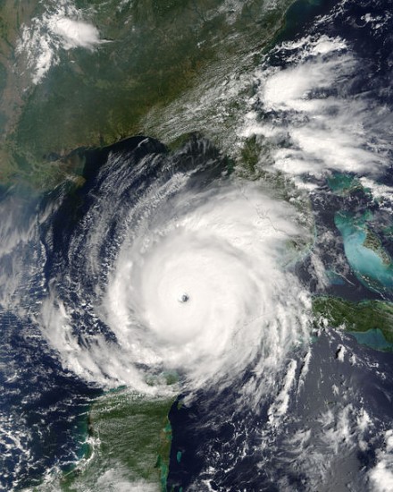
The forecast track continues to be remarkably stable from one computer model run to the next. It is expected to turn to a more north-northwesterly course tomorrow, then northerly in by Friday. That would bring the eye of the storm through the Bahamas and take it on a bee-line for the North Carolina Outer Banks on Saturday. At that time, it is still expected to be a major hurricane (Category 3 or higher) with top sustained winds close to 125 mph with higher gusts. Everyone in the eastern Carolinas, especially the Outer Banks, is bracing for what could be a major impact from Irene.
Beyond that, the forecast track now appears to either hug the Mid-Atlantic coastline or remain slightly offshore. If that track proves correct, and that’s a BIG IF, it may lose some intensity due to its interaction with land and outrunning its fuel supply from the warm tropical waters but it still should be a very dangerous storm.
GET THE LATEST BREAKING NEWS HERE -- SIGN UP FOR GOLOCAL FREE DAILY EBLASTThat track will also put Southern New England on the right side of the storm, typically the side of the strongest winds that would impact this area with gusts from the southeast, south and southwest … right up Narragansett Bay. If it hits around time of high tide, there should be some serious coastal and Bay flooding. The most dangerous tracks for us would be if the storm were to move up over Long Island, just to, our west or if it moved over us, right up Narragansett Bay. If, however, the storm veers more out to sea and passes us to the east, the affects would be much less severe and surfaces winds would be from the east and northeast. At this point it's a wait and see situation since pinpointing the exact track this far out is impossible.
Remember Irene is still nearly 1350 miles from Providence and is not expected to reach anywhere near us until late in the weekend. The track and intensity could change dramatically one way or the other during that extended time period. I will continue my updates and you can continue to follow Irene closely with our super Stormpulse Hurricane Tracker … https://www.golocalprov.com/index.php/weather/ .