

Henri Storm Surge Warning and Flood Watch — What to Know in RI
GoLocalProv News Team
Henri Storm Surge Warning and Flood Watch — What to Know in RI
SEE FORECAST BELOW
Henri is expected to generate 3 to 6 inches of rain across the watch area. Locally higher amounts are possible.
GET THE LATEST BREAKING NEWS HERE -- SIGN UP FOR GOLOCAL FREE DAILY EBLASTA Storm Surge Warning, Tropical Storm Warning, and Hurricane Watch are in effect for Block Island RI, Bristol RI, Eastern Kent RI, Newport RI, and Washington RI.
Flood Watch
National Weather Service Boston/Norton MA
416 AM EDT Sat Aug 21 2021
Hartford CT-Tolland CT-Windham CT-Western Franklin MA-Eastern-Franklin MA-Northern Worcester MA-Western Hampshire MA-Western-Hampden MA-Eastern Hampshire MA-Eastern Hampden MA-Southern Worcester MA-Northwest Providence RI-Southeast Providence RI-Western-Kent RI-Eastern Kent RI-Bristol RI-Washington RI-Newport RI-Block Island RI-
Including the cities of Union, West Warwick, Providence, Foster, Barre, Warwick, Orange, Windsor Locks, Smithfield, Springfield, Putnam, Milford, Charlemont, Vernon, Hartford, West Greenwich, Coventry, Willimantic, Newport, Bristol, Chesterfield, Fitchburg, New Shoreham, Blandford, Westerly, Greenfield, Narragansett, Northampton, Worcester, Amherst, and East Greenwich
416 AM EDT Sat Aug 21 2021
...FLOOD WATCH IN EFFECT FROM THIS EVENING THROUGH MONDAY MORNING...
The National Weather Service in Norton has issued a
* Flood Watch for portions of northern Connecticut, Massachusetts
and Rhode Island, including the following areas, in northern
Connecticut, Hartford CT, Tolland CT and Windham CT. In
Massachusetts, Eastern Franklin MA, Eastern Hampden MA, Eastern
Hampshire MA, Northern Worcester MA, Southern Worcester MA,
Western Franklin MA, Western Hampden MA and Western Hampshire MA.
In Rhode Island, Block Island RI, Bristol RI, Eastern Kent RI,
Newport RI, Northwest Providence RI, Southeast Providence RI,
Washington RI and Western Kent RI.
* From this evening through Monday morning.
* Henri is expected to generate 3 to 6 inches of rain across the
watch area. Locally higher amounts are possible.
* Rapid rises could be seen on smaller waterways. Urban and
poor-drainage flooding may also develop quickly.
PRECAUTIONARY/PREPAREDNESS ACTIONS...
You should monitor later forecasts and be alert for possible Flash
Flood Warnings. Those living in areas prone to flooding should be
prepared to take action should flooding develop.
Hurricane Local Statement
National Weather Service Boston/Norton MA AL082021
509 AM EDT Sat Aug 21 2021
This product covers Southern New England
**HENRI IS FORECAST TO IMPACT SOUTHERN NEW ENGLAND SUNDAY AND
MONDAY**
NEW INFORMATION
---------------
* CHANGES TO WATCHES AND WARNINGS:
- A Tropical Storm Warning has been issued for Hartford CT,
Tolland CT, and Windham CT
- The Hurricane Watch has been cancelled for Barnstable MA, Dukes
MA, Nantucket MA, Southern Bristol MA, and Southern Plymouth MA
* CURRENT WATCHES AND WARNINGS:
- A Storm Surge Warning, Tropical Storm Warning, and Hurricane
Watch are in effect for Block Island RI, Bristol RI, Eastern
Kent RI, Newport RI, and Washington RI
- A Tropical Storm Warning is in effect for Hartford CT, Tolland
CT, and Windham CT
- A Tropical Storm Warning and Hurricane Watch are in effect for
Western Kent RI
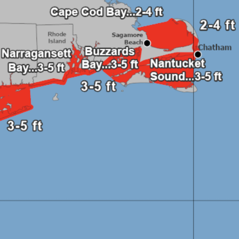
- A Storm Surge Warning is in effect for Barnstable MA and
Nantucket MA
- A Storm Surge Warning and Tropical Storm Warning are in effect
for Dukes MA, Southern Bristol MA, and Southern Plymouth MA
* STORM INFORMATION:
- About 590 miles south-southwest of Nantucket MA
- 33.1N 73.2W
- Storm Intensity 70 mph
- Movement North-northeast or 15 degrees at 12 mph
SITUATION OVERVIEW
------------------
Tropical Storm Henri is forecast to strengthen to a hurricane as it heads northward today. Henri is expected to make landfall near eastern Long Island Sunday as either a strong tropical storm or a lower end
Category 1 hurricane. Henri should weaken rapidly as it heads into Connecticut Sunday evening and slowly exits the region Monday. The main hazards include damaging winds, flooding rain, storm surge flooding,
and possibly a tornado.