

RI DOT Defends Release of 19th Century Maps, Says Part of 1,500 Pages Provided
GoLocalProv News Team
RI DOT Defends Release of 19th Century Maps, Says Part of 1,500 Pages Provided
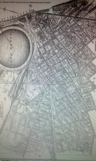
"Yesterday we learned that a public records request by Republican State Representative Patricia Morgan for information on proposed locations of toll gantries for Governor Raimondo's RhodeWorks program was responded to with an 1882 Atlas of the City of Providence. This Atlas was from an era when the horse and buggy was the main form of transportation," said Brandon Bell.
DOT Response
GET THE LATEST BREAKING NEWS HERE -- SIGN UP FOR GOLOCAL FREE DAILY EBLASTCharles Martin with the RI DOT fired back with the following explanation.
During discussion of repairs to the Route 6-10 interchange and impacts of the adjacent communities on either side of the highway, research was done on the configuration of city streets prior to the construction of the highways. Good planning is understanding the history of a project and its impact to communities over time.
As the APRA request asked for documents related to Route 6-10 construction, it was therefore discoverable by law, and RIDOT was compelled by law to transmit that document to Representative Morgan, along with an estimated 1,500 pages of documents as part of her APRA request.
10 Biggest Questions Facing Truck Tolls in RI

1.
Why won't the Governor define the proposal?
The Administration has put forth a number specifics that have changed since the original proposal, including the original “17-22” tolling locations changed to simply 17, and the reduction of toll amount from “$40-$50” to $30. However, the Administration just got the green light last month by the Feds to move forward with the loosely-defined plan, which included inquiring as to whether the undersides of bridges could be tolled — which the Feds said now.
Where will the tolls be located?
Where had they been considering bridge undersides, and why?
The loosely-defined plan has opened up the Administration to criticism that is moving to fast.

2.
When will RI get the details?
The Senate approved an updated version of the truck toll plan last General Assembly session. With no fall General Assembly session scheduled after much speculation, the lawmakers will ostensibly resume taking up the issue upon return in January or soon thereafter.
Will a more detail proposal be made public prior to the new session, or will the nuts and bolds — and gantries — be kept under lock and key until they’re unveiled at a Finance Committee hearing?

3.
Does 80% of the $500 Million really only go to cover 6/10 Interchange?
The administration is proposing a $500 million revenue bond - and anticipating refinancing of federal debt as well as an influx of new federal funds - to provide the basis to cover costs for the project dubbed “RhodeWorks."
However, of that $500 million bond, $400 million of it would go to just one project - the much needed repairs on the crumbling 6-10 connector, which represents less than 1% of all state roads.
Granted, not all of Rhode Island’s roads are in as dire condition at the 6/10 connector, but how much will the state have to spend — or bond — if $400 million goes to one project alone?

4.
Is RI stuck in a cycle for bonding?
With Rhode Island still smarting (will it ever not) from 38 Studios, the issue of a non-voter approved bond has taken on the appearance of a four-letter word.
The Republican Policy Group has put forth a no-toll — and no-bonding plan, but the administration continues to make that case that despite the costs associated with bond debt, it will cost less for RI to pay for the projects now.
In case you missed it, former Attorney General Arlene Violet wrote a scathing review of the state’s bonding industrial complex this week in the Valley Breeze, which is worth the read.

5.
Will the General Assembly consider alternative proposals?
The Republicans have their no-toll, no-bond, pay-go proposal. The Center for Freedom and Prosperity put forth a “P3” proposal for a public-private partnership. The Trucking Association put forth their own no-toll plan, with increased fees and taxes instead to pay for the infrastructure costs.
And State Rep. Doreen Costa has put forth a call to put any bond question before voters. How much, if any, of these other approaches will see the light of day at the General Assembly? The chances might be slim, but the opposition is vocal — and mobilized. Don’t expect bond opponents to go anywhere anytime soon.

6.
Can RI be assured it won't extend to autos?
The current proposal, as it sands, is to toll only trucks of a certain size — Class 8 to Class 13. However, that doesn’t have Rhode Islands worried that in the event of revenue shortfalls, that the classifications could be expanded.
Even if the Governor and General Assembly assured Rhode Islands that would never happen, there might be some discussion - and debate - around ensuring that’s the case. Raimondo worked to increase the cigarette tax (already the third highest in the country) this past session. The state’s revenue from gambling will continued to take a hit as competition from Massachusetts ramps up. Could — or should — a stipulation be put in any legislation that if the toll plan is to be expanded, it would need to go before voters?

7.
Do recent projection shortfalls (Medicaid and rental tax)) call into questions revenue projections?
Raimondo had anticipated saving just over $70 million in Medicaid reform in this year’s budget, but the state’s Office of Health and Human Services said the number they were looking was almost two million short of that mark, and the the state’s revenue and caseload estimating conference pegged gap as even higher, as first reported by the Providence Journal.
Most recently, WPRI noted that the rental home tax the Governor had touted fell $1 million short of expectations in the first month alone. The administration is depending on a revenue stream of $60 million year, which leads us to our next question.

8.
What happens if the state doesn't meet the revenue?
The projections put forth from the administration show that the state expects to collect $60 million a year from the tolls to pay for a thirty revenue bond. This was after the administration shifted gears from a 15 year, $700 million bond that was depended on $100 million in revenue a year.
The Republican Policy Group recently held a press conference on “missing inconvenient information,” at which is asserted that “half of the proposed tolls or $30 million comes from pass-through truckers, while the remaining half is paid by three sources: local trucks delivering out-of-state, instate/out-of-state trucks delivering in Rhode Island.
However, the impact study projects only $12.79 million in additional cost from inbound traffic and $5 million from all local and outbound traffic. The figures don't add up. Approximately, $12 million in annual toll revenue is unaccounted for.”
Does it create a 38 Studios issue?

9.
What happens if trucks go around?
RI Trucking Association spokesperson Bill Fischer has questioned repeatedly what would happen if the trucks simply bypass the state.
“We’d be on the hook for these bonds,” said Fischer. "We're saying charge us more in fees, focus on the diesel tax. We're worried about what no one has talked about, and that's evasion. It's a big deal because you don't need to go through Rhode Island to drive from New York to Boston. We still have to make the bond payments. These guys have computer programs that incorporate the fees and tolls.
The burden is being placed on the local guys." The Republican Policy Group has questioned whether diversion had been thoroughly vetted, as well. “Did the report account for diversion through Connecticut to avoid tolls as it relates to IFTA fees? Currently, truckers remit IFTA (International Fuel Tax Agreement) taxes to each state based on miles traveled. When they divert to avoid tolls, our state will lose these taxes. What is the corresponding loss in revenue?

10.
What if RI doesn't get matching funds?
As part of the overall project cost of just over $1 billion, $500 million would come from the revenue bond, $120 million would be achieved through existing bond refinancing, and $400 million is slated to come from the federal government for the 6-10 transit project.
Will that go by the wayside if the Feds don’t come through? What will that mean for future projects?


