

The Skiing Weatherman Conditions Report: February 6-9
Herb Stevens, GoLocalProv's Skiing Weatherman
The Skiing Weatherman Conditions Report: February 6-9

How it’ll play out
The first system streaked out to sea southeast of Cape Cod on Monday. Yesterday one area of low pressure took shape over the northwestern Gulf of Mexico near the Texas coast, and then moved up just west of the Appalachians to a position near Pittsburgh by morning. Now it would be a bad track for snow lovers in the Northeast if it were to continue on up to the eastern Great Lakes, but because the upper support for that low will continue to pivot eastward toward the ocean, a second area of low pressure will form somewhere near the mouth of Chesapeake Bay.
The original low will weaken as it wanders up toward western New York, while the new low will feed off the relative warmth of the water and the upper support overhead, and become the primary circulation center for this event in the Northeast. This transfer of energy from an inland low to a coastal low is known as a Miller “B” storm, named after Air Force Colonel Robert Miller, whose research differentiated between two different scenarios that lead to storms on the East coast. Here is a map that shows you the general ideal of how a Miller “B” storm works…
GET THE LATEST BREAKING NEWS HERE -- SIGN UP FOR GOLOCAL FREE DAILY EBLAST
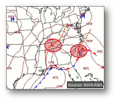
This time around, the secondary will have a good supply of cold air to work with over the Northeast, but it won’t be as deep or as cold as what we have seen the last couple of weeks. That will mean that coastal regions will see a mix of precipitation types from New York up to around Boston…north of there, even the coast will see snow. Because the storm will have it’s origin near the Gulf, this storm will be a juicy one, capable of producing heavy amounts of snow across much of the Northeast where it counts…in the hills. There is one factor that will limit the totals across far northern New England…the track of the storm will be off to the east-northeast, so amounts will taper down to 4 to 6 inches once you get north of roughly Route 2 in Maine and New Hampshire.
The Lincoln/Franconia Notch area, the North Conway region, as well as the mountains of western Maine up to Sunday River will pick up 6 to 10 inches; with 8 to 12 inches, falling from the Lakes region of New Hampshire southward to about the Mass Pike…Wachusett Mountain should be tagged with about 10-12 inches. Vermont will pick up substantial snow, as well, with 8-12 inches in the southern half of the state and 4 to 8 north of Route 4. The Berkshires are also in line for a solid 8-12 inches.
Looking ahead
In the wake of yesterday’s storm, a colder air mass will be drawn southward into the region, and the establishment of that colder air will set the stage for the next storm, which will also form near the Gulf before turning northeast for a run up the coast. The timing of the storm at this point appears to be later Saturday and Sunday, although that could change due to the fact that the upper air support for that system is somewhere up over Alaska as I write this post. It has a long way to go as it spins southeastward through the northern and central Rockies before producing the new surface system late this week. If you are about to make a trip to the Rockies, you will be happy to know that the upper level disturbance will produce some much needed snow in the West, too.
The weekend system looks like it will be a Miller “A” type storm, one whose primary comes up east of the Appalachians and continues up the coast toward the Maritimes. As a storm that comes from the Gulf breeding grounds, it should also be carrying a ton of moisture, and the potential exists for a snowfall that will be greater than what the midweek storm produces. Early indications are that the low will track more northeasterly than the midweek storm, so the far northern resorts should do better with the second event. Areas within 50 miles or so of the coast in southern New England could see a mix of snow and sleet at some point, but those areas should “net” snow. After that storm departs, the jet stream set up looks favorable for slightly colder than normal temperatures to be dominant through at least the middle of the month, which should sustain packed powder surface and set things up very nicely for the President’s Day holiday.
So, here comes a parade of storms that will produce multiple powder days, boost trail counts, cover some of the frozen granular spots that have been part of the landscape for a few weeks now, and build up base depths for the stretch run of the season. Arguably, the best run of snow conditions of the season is on the way…make your plans now.
Special events on the slopes this weekend
Wachusett Mountain, MA: Telemark Workshop (Thu.) and Masters Race Clinic (Fri.)
Saddleback, ME: Mountain Challenge (Sat.) Skin up and ski down
Attitash, NH: Freeride Series-Slopestyle (Sat.)
King Pine, NH: Night Skiing (Fri.), Kids Fun Race and Audubon Snowshoe Tour (Sat.)
Ragged Mt., NH: Ski East Giant Slalom Race (Sat.)
February Getaways in New England

Northeast Kingdom
What better way to celebrate the beauty of winter than to head up north for the week? Simple answer: there is none! Head up to the gorgeous mountains of Vermont’s Northeast Kingdom to enjoy all that the region has to offer. Try out Smuggler’s Notch Resort in Jeffersonville—one of the most well regarded family ski resorts in the entire country. Kids will enjoy full day programs and ski/board lessons, crafted specifically for them. Special needs programs are also available.
When you’re not hitting the slopes, enjoy a factory tour of Ben & Jerry’s flagship store, and even check out the flavor graveyard! And if beer and barbecue is more your style, be sure to check out Prohibition Pig in Waterbury!
Smuggler’s Notch: 4323 Vermont 108 South, Jeffersonville, Vermont. (802) 644-8851.

Mystic Aquarium
Make the trip to Connecticut for an adult treat at the Mystic Aquarium! On Saturday, February 15, the Saturday before February vacation, the aquarium will be hosting a South African wine dinner. Attendees will enjoy South African wines, hors d’oeuvres, and a 4-course dinner amongst African penguins and other beautiful marine life exhibits.
Later in the week, take the kids back to the Aquarium for a great day trip. Explore the exhibits and learn all about life under and near the sea!
55 Coogan Blvd., Mystic, CT. (860) 572-5955.

The White Mountains
The mountains of New England are a magical place to be any time of year—but they have a little something extra to offer when they are blanketed with snow. Head up to New Hampshire’s White Mountains region to see the beauty of winter in the mountains for yourself!
If you are traveling to the area with kids, look no farther than Lincoln’s Loon Mountain. Learners always get special savings with Loon’s Learner’s Passport. Even better, on select nights during February vacation week Loon will be hosting Fluorescent Nights, a special opportunity to ski or board after the sun goes down.
60 Loon Mountain Road, Lincoln, NH. (603) 745-8111.

Cape Cod
While people flock to the beaches of the Cape during the summer months, there is something special about being there off-season. Couples and families alike will enjoy quiet walks on the beach and memories that are made without the noise of thousands of tourists in the background.
What’s more is that it is much cheaper to stay on Cape Cod during the winter. If you want a resort, check out Cape Codder Resort & Spa in Hyannis. There’s an indoor wave pool, a spa, and more at the resort, and its proximity to beaches and shopping makes it super convenient.
1225 Iyannough Road, Hyannis, MA. (855) 861-4370.

Coastal Maine
The Coastal Maine region is another gem of New England summers, but the truth is that it is also gorgeous during the winter months. Take advantage of off-season rates in towns like Wells and Ogunquit and explore all that the area has to offer.
Take in world-famous scenery as you climb the Marginal Way in Ogunquit, enjoy a fresh hot lobster in Perkin’s Cove, and walk along Well’s Beach for a quiet retreat from the rest of the world.

Roger Williams Park Zoo
Believe it or not, Providence’s Roger Williams Park Zoo is open 12 months a year! Plan a trip to the Zoo with the little ones to help get rid of some of that pent up energy—and learn something while doing it!
Roger Williams Park Zoo is one of the oldest zoos in the country and is home to a bounty of animals—many of which enjoy the cold. Animals you may see outdoors during the winter include Bald Eagles, Moon Bears, bison, camels, and many others. There is no better time to enjoy the Zoo than February vacation—admission is half priced throughout the month!
1000 Elmwood Avenue, Providence, RI. (401) 941-4998.

Essex Steam Train
The first weekend of February vacation head to Essex, Connecticut for the adventure of a lifetime. February 15 & 16, Essex Steam Train & Riverboat will be having its annual Eagle Flyer event.
Attendees will take a 2 1/2 hour-long eco-excursion aboard the Eagle Flyer out of Essex Station in Essex...pulled by a vintage diesel train. During the ride, naturalists will share information regarding the Bald Eagle’s migration through the region. Make sure to pack your binoculars so you can spot the majestic creatures in the wild!
1 Railroad Avenue, Essex, CT. (860) 767-0103.

Jiminy Peak
Head to the Berkshires for a snowy getaway during the week of February vacation. Check out Jiminy Peak in the quaint Western Massachusetts town of Hancock—it’s perfect for families!
Enjoy a day on the slopes, but be sure to leave time to explore all that the Berkshires have to offer as well! Local favorites include the Norman Rockwell Museum, Berkshire Museum, Hancock Shaker Village, and more!
37 Corey Road, Hancock, MA. (413) 738-5500.

Burlington, VT
For a getaway that will offer the best of shopping, winter sports, culture and food, be sure to check out the Northern Vermont city of Burlington. Nestled against Lake Champlain, Burlington is home to world class colleges, delicious eateries, and a pristine natural setting.
While you’re in the area, there is one place that you should absolutely experience: Church Street. Church Street is a cobblestone street not open to traffic in the heart of the city. It is home to gorgeous little boutiques, warm and inviting restaurants, and a great cultural atmosphere. Other highlights of the area include the waterfront, Dobra Tea, and Higher Ground.

Block Island
Enjoy a retreat from the rest of the world on Rhode Island’s Block Island! Enjoy the sights and sounds of the island—from calm walks on the beach to sightseeing in the interior region. Bring bicycles to get through town, and be ready to enjoy the beautiful natural setting that will surround you.
Block Island is not home to an amusement park, nor is there a fast food joint in sight. Block Island is a place to go to make your own memories—and have fun doing it!


