

HURRICANE UPDATE MONDAY AFTERNOON: Height Of The Storm Here Now In RI
John Ghiorse, GoLocalProv Meterologist
HURRICANE UPDATE MONDAY AFTERNOON: Height Of The Storm Here Now In RI
A truly great natural disaster
Winds have increased to 90 mph near the center and will maintain that strength until landfall. This is truly a great natural disaster as several communities in the Mid-Atlantic are already fully or partially underwater, including Atlantic City. And the worst is yet to come.
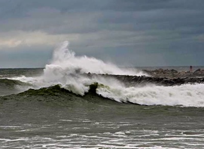
Rhode Island: worst from now 'til later tonight
The worst part of the storm for us will be from the present time until 8 or 9 pm. East to northeast winds will gust over 50 mph with a few gusts to 65-75 mph especially near the coast and over higher terrain inland. Needless to say power outages on a widespread basis are very likely. The coast and Narragansett Bay communities will experience the worst of Sandy locally with major flooding and destructive wave damage. A coastal surge of 4-6 feet over mean high water is expected this evening as high tide approaches at 9 pm. That surge could reach 7-8 feet in the upper portion of Narragansett Bay. As indicated earlier, there will be bands of heavy rain moving through the area but river and stream flooding is not expected to be a big problem.
GET THE LATEST BREAKING NEWS HERE -- SIGN UP FOR GOLOCAL FREE DAILY EBLASTThe storm will diminish after midnight but gusty winds and scattered showery periods could persist into Wednesday.
Caution: this is the height of the storm
The next few hours will be the height of the storm for us. Please resist the temptation to go out and see what’s going on. I will continue to have updates on a regular basis.
Photo: Jerri Moon Cantone.