

Is Rhode Island Due for a Big Hurricane?
GoLocalProv News Team and Kate Nagle
Is Rhode Island Due for a Big Hurricane?
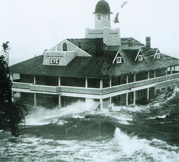
After getting hit hard last by Hurricane Sandy in 2012 -- is Rhode Island, which was named one of the ten most vulnerable hurricane cities in the U.S. the following year -- due for another big one?
"One of the historical facts about Rhode Island is we've tended to get our biggest hurricanes in seasons that haven't been particularly active," said GoLocalProv meteorologist John Ghiorse, who had previously been at WJAR-10 for over forty years.
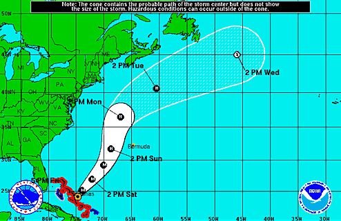
GET THE LATEST BREAKING NEWS HERE -- SIGN UP FOR GOLOCAL FREE DAILY EBLAST"There's an outside low percentage it could hook back, but that's a remote possibility," said Ghiorse of Joaquin's path on Friday. "People shouldn't give up on it, and of course, we're getting late into the [hurricane] season. It's been a slow season. October hurricanes in New England are fairly rare but not impossible."
El Nino Factor
Ghiorse said that predicting hurricane seasons usually occurs just months prior, with anything further out being more difficult.
"It's usually a matter of months, not years," said Ghiorse of forecasting hurricane trends. "This El Nino was actually seen coming a while back, but now the big thing is when it's going to recede."
According to NOAA, El Nino is characterized by unusually warm temperatures, whereas La Niña by unusually cool temperatures in the equatorial Pacific.
Ghiose spoke to the El Nino effect this year, as it has impacted the hurricane season -- and what it means for the winter in New England.
"So in terms of an El Nino, you can see one coming, and its cyclical with the weather, and the climate -- now it's a matter of when it's going to recede," said Ghiorse. "As far as we're concerned, if it stays, it means that it won't be as severely cold as last winter, but that would be hard to beat. Usually [with El Nino] you get a winter that's not as cold, it can be stormy, but it would more likely be snow to rain or vice versa, it tends to be that kind of thing."
Trends in Storm Tracking
Veteran meteorologist Ghiorse said that efforts to track future hurricanes still rely on technology that's been in place for some time, but the way that data is used varies -- as does its outcome.
"Satellites are still the primary tool to use, simply because in that part of the Atlantic, there are few weather stations," said Ghiorse. "Obviously the satellite technology provides us with better and better info, and we still fly aircraft into hurricanes to get data, but the advances have been in the models that you put the data into. Even those, as shown with this storm, they'll run a dozen models or more, and they'll come up with a dozen different scenarios. It all depends on the data you put in --that's the data you get out."
Ghiorse said that even differences in modeling played a factor.
"The European model is a bit more effective model than what we use," said Ghiorse. "From the beginning, it's been taking the storm out to sea, while some of the American models have taken it into the mid-atlantic [states]. For whatever reason, the physics seem to work out better with the European model, I don't know why we haven't emulated that model more. I'm more of a practical, hands on guys, I can't pretend to know how to fix it."
While news reports and social media have both hyped -- and down-played -- the upcoming storm, Ghiorse said from his home in Florida that people in New England should remain on watch.
"When they're still that far away, there's uncertainty," said Ghiorse of hurricanes forming in the tropics. "It's good for people up north to keep an eye on it, but to be panicked is not helpful. It's something we watch, and right now, [Hurricane Joaquin] looks like it's going to peter out [to sea]. But people shouldn't give up on it. "
Natural Disasters: RI's Most At Risk and Vulnerable Communities

#39 Little Compton
Natural Hazard Scores
Wind Score: 160
Flood Score: 18
Earthquake Score: 60
Tornado Score: 16
Snow Score: 50
Total Score: 424
Flood Damage
Rank: 14
Acres at Risk of Flooding: 2,516
Percent of Total Acres in Community at Risk: 16.78%
Hurricane Coastal Flooding
Number of Residents in Evac. Zone: 1,160
Number of Buildings at Risk: 187
Photo: Flickr/Al Carmadella Jr.

#38 Richmond
Natural Hazard Scores
Wind Score: 200
Flood Score: 18
Earthquake Score: 90
Tornado Score: 24
Snow Score: 75
Total Score: 587
Flood Damage
Rank: 24
Acres at Risk of Flooding: 2,945
Percent of Total Acres in Community at Risk: 11.35%
Hurricane Coastal Flooding
Number of Residents in Evac. Zone: N/A
Number of Buildings at Risk: N/A

#37 Exeter
Natural Hazard Scores
Wind Score: 240
Flood Score: 0
Earthquake Score: 90
Tornado Score: 24
Snow Score: 75
Total Score: 609
Flood Damage
Rank: 36
Acres at Risk of Flooding: 2,190
Percent of Total Acres in Community at Risk: 5.78%
Hurricane Coastal Flooding
Number of Residents in Evac. Zone: N/A
Number of Buildings at Risk: N/A
Photo: Flickr/UCL Mathematical

#36 West Greenwich
Natural Hazard Scores
Wind Score: 240
Flood Score: 0
Earthquake Score: 90
Tornado Score: 24
Snow Score: 75
Total Score: 609
Flood Damage
Rank: 39
Acres at Risk of Flooding: 1,197
Percent of Total Acres in Community at Risk: 3.62%
Hurricane Coastal Flooding
Number of Residents in Evac. Zone: N/A
Number of Buildings at Risk: N/A
Photo: Flickr/born1945

#35 New Shoreham
Natural Hazard Scores
Wind Score: 300
Flood Score: 27
Earthquake Score: 90
Tornado Score: 24
Snow Score: 75
Total Score: 696
Flood Damage
Rank: 13
Acres at Risk of Flooding: 1,220
Percent of Total Acres in Community at Risk: 17.3%
Hurricane Coastal Flooding
Number of Residents in Evac. Zone: 840
Number of Buildings at Risk: 20
Photo: Flickr/Al Camardella Jr.

#34 Foster
Natural Hazard Scores
Wind Score: 180
Flood Score: 18
Earthquake Score: 120
Tornado Score: 32
Snow Score: 200
Total Score: 790
Flood Damage
Rank: 28
Acres at Risk of Flooding: 2,659
Percent of Total Acres in Community at Risk: 7.94%
Hurricane Coastal Flooding
Number of Residents in Evac. Zone: N/A
Number of Buildings at Risk: N/A
Photo: Flickr/US Geological Survey

#33 Jamestown
Natural Hazard Scores
Wind Score: 480
Flood Score: 54
Earthquake Score: 180
Tornado Score: 48
Snow Score: 150
Total Score: 1,272
Flood Damage
Rank: 20
Acres at Risk of Flooding: 766
Percent of Total Acres in Community at Risk: 11.95%
Hurricane Coastal Flooding
Number of Residents in Evac. Zone: 3,910
Number of Buildings at Risk: 108
Photo: Flickr/NASA Goddard

#32 Hopkinton
Natural Hazard Scores
Wind Score: 600
Flood Score: 54
Earthquake Score: 210
Tornado Score: 56
Snow Score: 175
Total Score: 1,515
Flood Damage
Rank: 21
Acres at Risk of Flooding: 3,412
Percent of Total Acres in Community at Risk: 11.86%
Hurricane Coastal Flooding
Number of Residents in Evac. Zone: N/A
Number of Buildings at Risk: N/A

#31 North Smithfield
Natural Hazard Scores
Wind Score: 480
Flood Score: 27
Earthquake Score: 210
Tornado Score: 56
Snow Score: 350
Total Score: 1,543
Flood Damage
Rank: 26
Acres at Risk of Flooding: 1,727
Percent of Total Acres in Community at Risk: 10.63%
Hurricane Coastal Flooding
Number of Residents in Evac. Zone: N/A
Number of Buildings at Risk: N/A
Photo: Flickr/ilovemypit

#30 Charlestown
Natural Hazard Scores
Wind Score: 680
Flood Score: 144
Earthquake Score: 210
Tornado Score: 56
Snow Score: 175
Total Score: 1,685
Flood Damage
Rank: 4
Acres at Risk of Flooding: 9,276
Percent of Total Acres in Community at Risk: 34.08%
Hurricane Coastal Flooding
Number of Residents in Evac. Zone: 2,510
Number of Buildings at Risk: 838

#29 Glocester
Natural Hazard Scores
Wind Score: 500
Flood Score: 27
Earthquake Score: 240
Tornado Score: 64
Snow Score: 400
Total Score: 1,711
Flood Damage
Rank: 34
Acres at Risk of Flooding: 2,271
Percent of Total Acres in Community at Risk: 6.2%
Hurricane Coastal Flooding
Number of Residents in Evac. Zone: N/A
Number of Buildings at Risk: N/A
Photo: Flickr/Michael Dolan

#28 East Greenwich
Natural Hazard Scores
Wind Score: 720
Flood Score: 63
Earthquake Score: 270
Tornado Score: 72
Snow Score: 225
Total Score: 1,890
Flood Damage
Rank: 17
Acres at Risk of Flooding: 1,500
Percent of Total Acres in Community at Risk: 14.03%
Hurricane Coastal Flooding
Number of Residents in Evac. Zone: 1,240
Number of Buildings at Risk: N/A
Photo: Flickr/Sean Naber

#27 Scituate
Natural Hazard Scores
Wind Score: 500
Flood Score: 99
Earthquake Score: 270
Tornado Score: 72
Snow Score: 450
Total Score: 1,931
Flood Damage
Rank: 11
Acres at Risk of Flooding: 6,368
Percent of Total Acres in Community at Risk: 17.98%
Hurricane Coastal Flooding
Number of Residents in Evac. Zone: N/A
Number of Buildings at Risk: N/A
Photo: Flickr/US Geological Survey

#26 Middletown
Natural Hazard Scores
Wind Score: 800
Flood Score: 36
Earthquake Score: 300
Tornado Score: 80
Snow Score: 250
Total Score: 2,066
Flood Damage
Rank: 37
Acres at Risk of Flooding: 499
Percent of Total Acres in Community at Risk: 5.63%
Hurricane Coastal Flooding
Number of Residents in Evac. Zone: 2,012
Number of Buildings at Risk: N/A
Photo: Flickr/Ani Carrington

#25 Central Falls
Natural Hazard Scores
Wind Score: 740
Flood Score: 36
Earthquake Score: 300
Tornado Score: 80
Snow Score: 500
Total Score: 2,256
Flood Damage
Rank: 16
Acres at Risk of Flooding: 121
Percent of Total Acres in Community at Risk: 14.58%
Hurricane Coastal Flooding
Number of Residents in Evac. Zone: N/A
Number of Buildings at Risk: N/A

#24 Tiverton
Natural Hazard Scores
Wind Score: 880
Flood Score: 54
Earthquake Score: 330
Tornado Score: 88
Snow Score: 275
Total Score: 2,287
Flood Damage
Rank: 22
Acres at Risk of Flooding: 2,335
Percent of Total Acres in Community at Risk: 11.51%
Hurricane Coastal Flooding
Number of Residents in Evac. Zone: 3,080
Number of Buildings at Risk: 191

#23 Warren
Natural Hazard Scores
Wind Score: 800
Flood Score: 198
Earthquake Score: 330
Tornado Score: 88
Snow Score: 275
Total Score: 2,351
Flood Damage
Rank: 5
Acres at Risk of Flooding: 1,431
Percent of Total Acres in Community at Risk: 33.99%
Hurricane Coastal Flooding
Number of Residents in Evac. Zone: 7,520
Number of Buildings at Risk: 534

#22 Lincoln
Natural Hazard Scores
Wind Score: 740
Flood Score: 45
Earthquake Score: 360
Tornado Score: 96
Snow Score: 600
Total Score: 2,561
Flood Damage
Rank: 35
Acres at Risk of Flooding: 752
Percent of Total Acres in Community at Risk: 6.12%
Hurricane Coastal Flooding
Number of Residents in Evac. Zone: N/A
Number of Buildings at Risk: N/A

#21 Narragansett
Natural Hazard Scores
Wind Score: 1,180
Flood Score: 198
Earthquake Score: 390
Tornado Score: 104
Snow Score: 325
Total Score: 2,977
Flood Damage
Rank: 2
Acres at Risk of Flooding: 4,224
Percent of Total Acres in Community at Risk: 39.2
Hurricane Coastal Flooding
Number of Residents in Evac. Zone: 9,030
Number of Buildings at Risk: N/A

#20 Portsmouth
Natural Hazard Scores
Wind Score: 1,120
Flood Score: 216
Earthquake Score: 420
Tornado Score: 112
Snow Score: 350
Total Score: 3,058
Flood Damage
Rank: 7
Acres at Risk of Flooding: 4,238
Percent of Total Acres in Community at Risk: 26.64
Hurricane Coastal Flooding
Number of Residents in Evac. Zone: 6,530
Number of Buildings at Risk: 1,078
Photo: Flickr/Core Burn

#19 Smithfield
Natural Hazard Scores
Wind Score: 920
Flood Score: 72
Earthquake Score: 420
Tornado Score: 112
Snow Score: 700
Total Score: 3,094
Flood Damage
Rank: 30
Acres at Risk of Flooding: 1,201
Percent of Total Acres in Community at Risk: 6.74%
Hurricane Coastal Flooding
Number of Residents in Evac. Zone: N/A
Number of Buildings at Risk: N/A

#18 Barrington
Natural Hazard Scores
Wind Score: 860
Flood Score: 243
Earthquake Score: 420
Tornado Score: 112
Snow Score: 600
Total Score: 3,066
Flood Damage
Rank: 1
Acres at Risk of Flooding: 2,417
Percent of Total Acres in Community at Risk: 40.97%
Hurricane Coastal Flooding
Number of Residents in Evac. Zone: 13,890
Number of Buildings at Risk: 784

#17 Bristol
Natural Hazard Scores
Wind Score: 1,200
Flood Score: 135
Earthquake Score: 480
Tornado Score: 128
Snow Score: 400
Total Score: 3,303
Flood Damage
Rank: 8
Acres at Risk of Flooding: 1,745
Percent of Total Acres in Community at Risk: 26.28
Hurricane Coastal Flooding
Number of Residents in Evac. Zone: 5,330
Number of Buildings at Risk: 483

#16 Coventry
Natural Hazard Scores
Wind Score: 1,160
Flood Score: 81
Earthquake Score: 480
Tornado Score: 128
Snow Score: 550
Total Score: 3,359
Flood Damage
Rank: 38
Acres at Risk of Flooding: 2,147
Percent of Total Acres in Community at Risk: 5.26%
Hurricane Coastal Flooding
Number of Residents in Evac. Zone: N/A
Number of Buildings at Risk: N/A

#15 Burrillville
Natural Hazard Scores
Wind Score: 906
Flood Score: 63
Earthquake Score: 510
Tornado Score: 136
Snow Score: 850
Total Score: 3,539
Flood Damage
Rank: 32
Acres at Risk of Flooding: 2,394
Percent of Total Acres in Community at Risk: 6.39
Hurricane Coastal Flooding
Number of Residents in Evac. Zone: N/A
Number of Buildings at Risk: N/A

#14 Johnston
Natural Hazard Scores
Wind Score: 1,180
Flood Score: 18
Earthquake Score: 510
Tornado Score: 136
Snow Score: 850
Total Score: 3,714
Flood Damage
Rank: 25
Acres at Risk of Flooding: 1,677
Percent of Total Acres in Community at Risk: 10.7%
Hurricane Coastal Flooding
Number of Residents in Evac. Zone: N/A
Number of Buildings at Risk: N/A

#13 South Kingstown
Natural Hazard Scores
Wind Score: 1,580
Flood Score: 171
Earthquake Score: 540
Tornado Score: 144
Snow Score: 450
Total Score: 3,965
Flood Damage
Rank: 6
Acres at Risk of Flooding: 12,168
Percent of Total Acres in Community at Risk: 29.51
Hurricane Coastal Flooding
Number of Residents in Evac. Zone: 7,310
Number of Buildings at Risk: 1,315

#12 Cumberland
Natural Hazard Scores
Wind Score: 1,180
Flood Score: 117
Earthquake Score: 600
Tornado Score: 160
Snow Score: 1,000
Total Score: 4,257
Flood Damage
Rank: 23
Acres at Risk of Flooding: 2,098
Percent of Total Acres in Community at Risk: 11.46%
Hurricane Coastal Flooding
Number of Residents in Evac. Zone: N/A
Number of Buildings at Risk: N/A

#11 Westerly
Natural Hazard Scores
Wind Score: 1,880
Flood Score: 189
Earthquake Score: 570
Tornado Score: 152
Snow Score: 475
Total Score: 4,406
Flood Damage
Rank: 9
Acres at Risk of Flooding: 5,604
Percent of Total Acres in Community at Risk: 26.15%
Hurricane Coastal Flooding
Number of Residents in Evac. Zone: 7,120
Number of Buildings at Risk: 1,342

#10 West Warwick
Natural Hazard Scores
Wind Score: 1,480
Flood Score: 99
Earthquake Score: 660
Tornado Score: 176
Snow Score: 925
Total Score: 4,660
Flood Damage
Rank: 19
Acres at Risk of Flooding: 629
Percent of Total Acres in Community at Risk: 12.21%
Hurricane Coastal Flooding
Number of Residents in Evac. Zone: N/A
Number of Buildings at Risk: N/A

#9 North Providence
Natural Hazard Scores
Wind Score: 1,400
Flood Score: 81
Earthquake Score: 690
Tornado Score: 184
Snow Score: 1,150
Total Score: 4,885
Flood Damage
Rank: 33
Acres at Risk of Flooding: 238
Percent of Total Acres in Community at Risk: 6.3%
Hurricane Coastal Flooding
Number of Residents in Evac. Zone: N/A
Number of Buildings at Risk: N/A

#8 North Kingstown
Natural Hazard Scores
Wind Score: 1,760
Flood Score: 297
Earthquake Score: 690
Tornado Score: 184
Snow Score: 575
Total Score: 4,886
Flood Damage
Rank: 10
Acres at Risk of Flooding: 5,538
Percent of Total Acres in Community at Risk: 19.12%
Hurricane Coastal Flooding
Number of Residents in Evac. Zone: 7,820
Number of Buildings at Risk: 850
Photo: Flickr/Jessica Merz

#7 Newport
Natural Hazard Scores
Wind Score: 1,880
Flood Score: 306
Earthquake Score: 720
Tornado Score: 192
Snow Score: 600
Total Score: 5,138
Flood Damage
Rank: 3
Acres at Risk of Flooding: 2,078
Percent of Total Acres in Community at Risk: 37.24%
Hurricane Coastal Flooding
Number of Residents in Evac. Zone: 10,590
Number of Buildings at Risk: 993
Photo: Flickr/ChalkyLives

#6 Woonsocket
Natural Hazard Scores
Wind Score: 2,260
Flood Score: 99
Earthquake Score: 1,110
Tornado Score: 296
Snow Score: 1,850
Total Score: 7,835
Flood Damage
Rank: 29
Acres at Risk of Flooding: 356
Percent of Total Acres in Community at Risk: 6.95%
Hurricane Coastal Flooding
Number of Residents in Evac. Zone: N/A
Number of Buildings at Risk: N/A

#5 East Providence
Natural Hazard Scores
Wind Score: 2,720
Flood Score: 225
Earthquake Score: 1,410
Tornado Score: 376
Snow Score: 2,350
Total Score: 9,901
Flood Damage
Rank: 12
Acres at Risk of Flooding: 1,610
Percent of Total Acres in Community at Risk: 17.37%
Hurricane Coastal Flooding
Number of Residents in Evac. Zone: 7,430
Number of Buildings at Risk: N/A

#4 Cranston
Natural Hazard Scores
Wind Score: 3,820
Flood Score: 360
Earthquake Score: 1,950
Tornado Score: 520
Snow Score: 3,250
Total Score: 13,800
Flood Damage
Rank: 27
Acres at Risk of Flooding: 1,541
Percent of Total Acres in Community at Risk: 8.25%
Hurricane Coastal Flooding
Number of Residents in Evac. Zone: 2,330
Number of Buildings at Risk: 640

#3 Pawtucket
Natural Hazard Scores
Wind Score: 4,880
Flood Score: 117
Earthquake Score: 2,160
Tornado Score: 576
Snow Score: 3,600
Total Score: 15,653
Flood Damage
Rank: 31
Acres at Risk of Flooding: 392
Percent of Total Acres in Community at Risk: 6.7%
Hurricane Coastal Flooding
Number of Residents in Evac. Zone: 1,150
Number of Buildings at Risk: N/A

#2 Warwick
Natural Hazard Scores
Wind Score: 5,400
Flood Score: 684
Earthquake Score: 2,400
Tornado Score: 640
Snow Score: 2,875
Total Score: 16,799
Flood Damage
Rank: 15
Acres at Risk of Flooding: 3,923
Percent of Total Acres in Community at Risk: 16.51%
Hurricane Coastal Flooding
Number of Residents in Evac. Zone: 28,760
Number of Buildings at Risk: 2,594

#1 Providence
Natural Hazard Scores
Wind Score: 10,980
Flood Score: 486
Earthquake Score: 5,850
Tornado Score: 1,560
Snow Score: 9,750
Total Score: 40,326
Flood Damage
Rank: 18
Acres at Risk of Flooding: 1,669
Percent of Total Acres in Community at Risk: 13.58%
Hurricane Coastal Flooding
Number of Residents in Evac. Zone: 1,010
Number of Buildings at Risk: 481


